Santa Catarina is now considered one of the richest states in the country in terms of natural beauty and cultural diversity. It occupies a strategic place in the South region and carries important passages in its colonization and history. In this panorama, we highlight with special pride Serra Catarinense, considered one of the most beautiful destinations on the national and international scene.
Its municipalities, with typical characteristics of the “mountain way”, remind us of a singular simplicity and, at the same time, of people who have always fought to preserve their roots and customs.
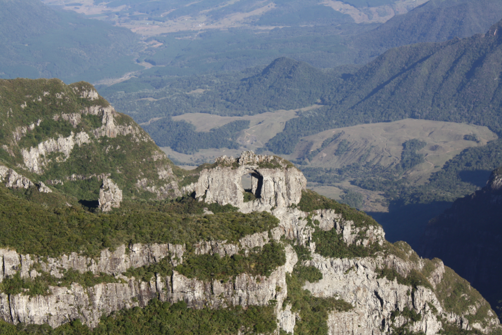
The mountain topography and nature are exuberant and rich in springs, rivers and clear waterfalls, gigantic canyons and mountain ranges with unbelievable cuts.
Read too:
tourist attractions in Santa Catarina
Discover the 8 best destinations in the Santa Catarina mountains
There are the favorite places of tourists who, during the winter, go in search of very cold weather and the possibility of snow, among these places are: Bom Jardim da Serra, São Joaquim, Urubici, and Urupema.
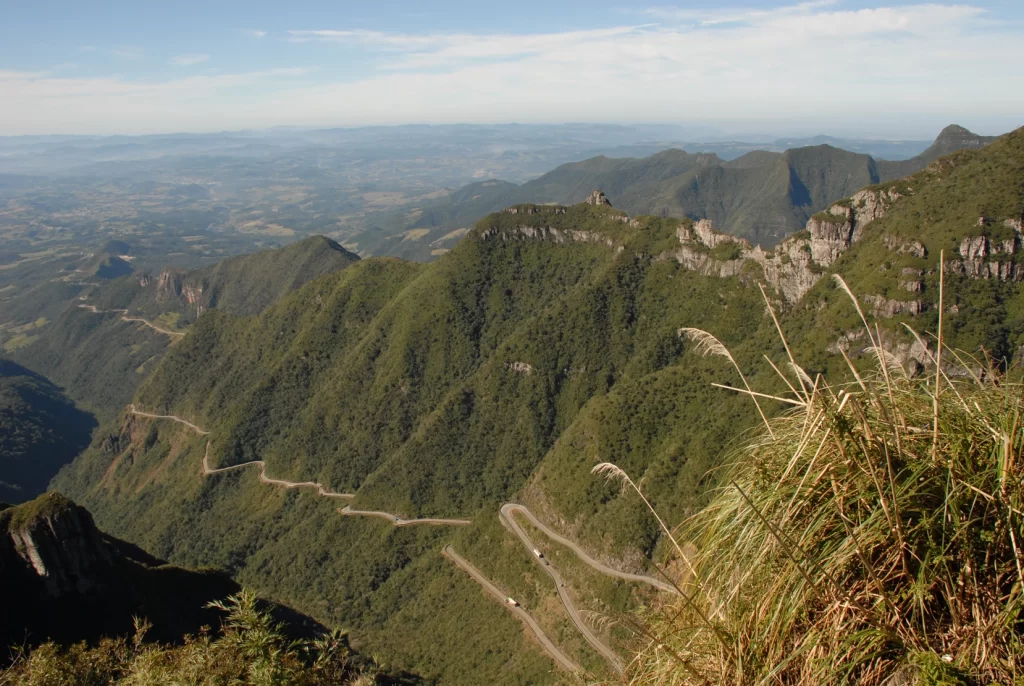
In addition, nature and the great mountains give a spectacle, among the most winding and fearless roads in the world are: The Serra do Rio do Rastro and the Serra do Corvo Branco are the two most amazing.
In these fantastic places you can find beautiful hotels, inns and wonderful restaurants with fireplaces and that delicious wine. Below I will describe the best destinations in the Santa Catarina mountains and its charms!
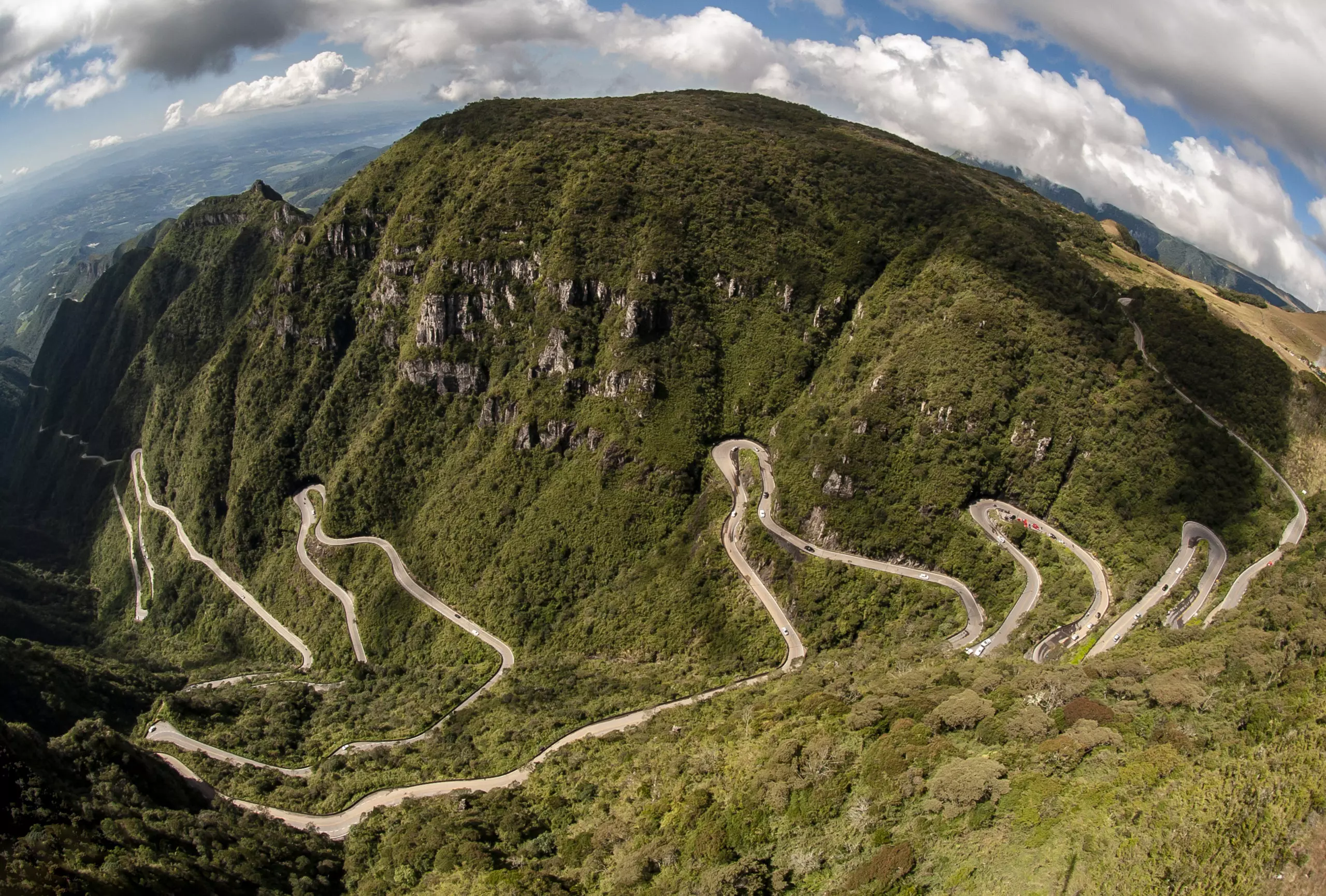
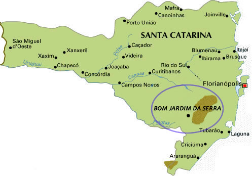
Bom Jardim da Serra
Visitors looking for Serra do Rio do Rastro find one of the most beautiful landscapes in Santa Catarina. One of the options is the small municipality of Bom Jardim da Serra, which has a mountain range of 1,467 meters high, canyons, apple orchards and animals of various species.
The preserved nature is a kind of refuge for hares, wild cats, ocelots and pumas, the latter more difficult to be seen by visitors.
Coatis, on the other hand, are not frightened by the presence of tourists and even accept being fed (it is forbidden to give food other than fruit).
How to get to Bom Jardim da Serra
To get there, it is possible to access it through several places, but viewing the mountain will also have different ways, accessing through Criciúma and Tubarão you will go up the mountain, if you choose the other roads you will go down.
BR 101 with access via Rod SC-444 in Criciúma
BR 101 with access via Rod SC-438 in Tubarão
BR 116 with access via Rod SC-438 in Lages
BR 282 with access via Rod SC-438 in Lages
BR 282 with access via Rod SC-430 in Bom Retiro
Municipal Road São José dos Absentes – RS
The path to Bom Jardim da Serra – a road in the middle of mountains covered by native forest – provides a tour that delights anyone. The road has 34 kilometers.
THE ascent starts at Laura Müller and at the top of the mountain stands Bom Jardim da Serra, a small and cozy town. Upon reaching the top of the Serra, it is impossible not to stop.
How to get to Bom Jardim da Serra
It is possible to go up or down the mountain by car, motorbike, bus or bicycle.
If you live in another state, there is the possibility of coming by plane and then renting a car. Enjoy and check the prices by clicking on the banner!

The distance from the airports to Bom Jardim da Serra are:
Criciúma and Lages Airports – 100 km
Hercílio Luz International Airport in Florianópolis – 230 km
Jaguaruna and Correa Pinto airports being implemented – 140 km

PROMO TICKETS – Access the search engine for promotional airline tickets with the best prices on the market! Pay up to 10x!
MAKE YOUR SEARCH FOR CHEAP FLIGHTS!
Viewpoint of Bom Jardim da Serra
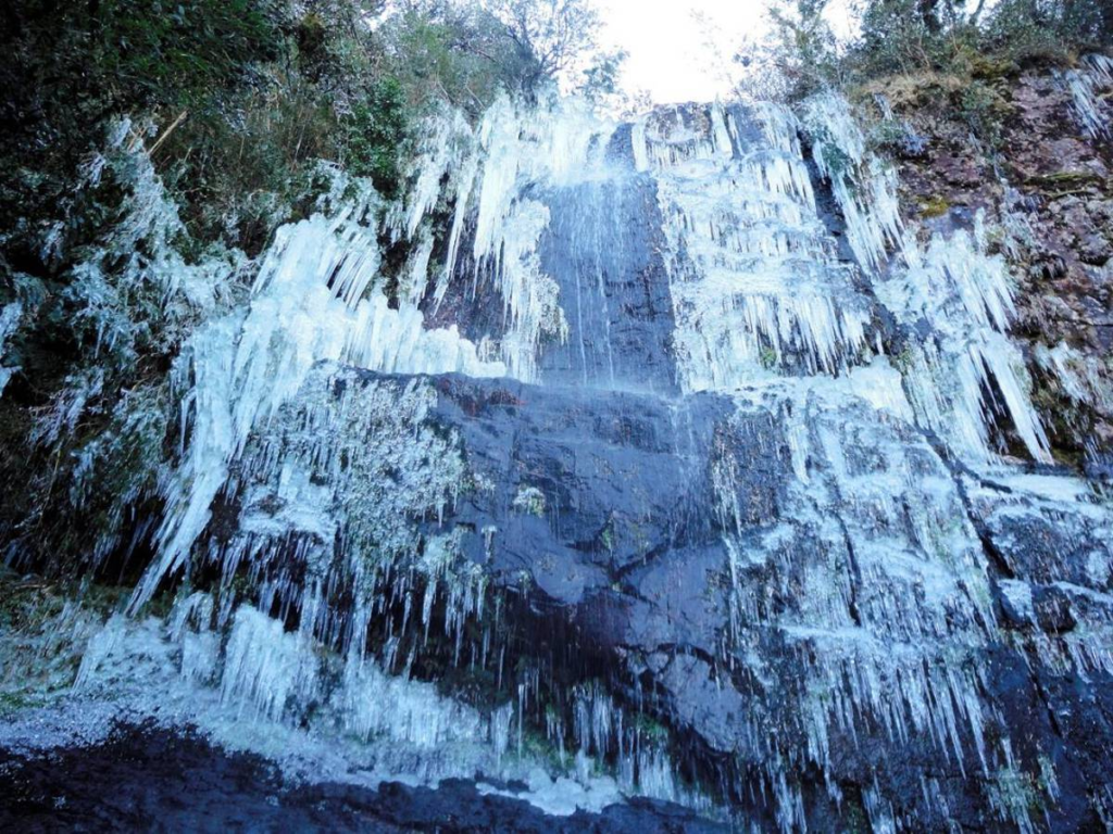
At the highest point is a lookout, from where it is possible to see all the curves of the road in the middle of the native forest. Bom Jardim is also known as the Capital of the waters, there are 18 rivers that originate in the municipality, all tributaries of the Pelotas River.
There are more than 30 waterfalls. On cold days, in some places, the waters are frozen, providing an unusual scenario. In the region's lakes, ducks walk on the pieces of ice formed on top of the water.
Saint joaquim
São Joaquim, known as the apple capital, is located 45 kilometers from Bom Jardim da Serra.
The city that is known for being one of the coldest in Brazil and is attracted to snow.
Days with mild temperatures are ideal for getting to know the Apple National Park, where you can find handicrafts Serrano plateau. For those who like to appreciate nature, a good tip is to visit the Echologic Park.
There are 30 hectares covered by forest, with several trails, those who decide to discover the forest must always be accompanied by a guide. The park is on the banks of the SC-438.
How to get to São Joaquim
Leaving São Paulo: you will travel around 852 km. The trip usually takes approximately 10 hours and 30 minutes if there is no traffic. Along the way, you will pass through the highways BR 272, BR 116 and SC 114.
Leaving Rio de Janeiro: the journey to São Joaquim will be approximately 1,285 km. The trip usually takes about 15 hours without traffic. Along the way, you will pass through the highways BR 114 and SC 114.
Leaving Curitiba: the journey to São Joaquim will be around 441 km. The trip usually lasts approximately 6 hours without traffic. Along the way, you will pass through the highways BR 116 and SC 114.
Leaving from Porto Alegre: the journey to São Joaquim will take around 322 km. The trip usually takes approximately 4 hours and 30 minutes without traffic. Along the way, you will pass through the highways BR 116, RS 239 and RS 020.
To get to São Joaquim you need to go by car, motorbike or bus.
What is the closest airport to Sao Joaquim?
ISMAEL NUNES AIRPORT located on Highway SC-110, in a rural area of the municipality, about 9.5 km from the city center which is located in the mountainous region of the State of Santa Catarina.
What to do in São Joaquim 1 day?
Here are some options to enjoy São Joaquim in one day:
- mother church in Saint joaquim and Praça João Ribeiro, both are opposite each other, the Church, which began construction in 1918, is attractive to appreciate it up close, as the Square has some sculptures and you can take the opportunity to rest a little.
- Belvedere (Viewpoint of the city of Saint joaquim), this viewpoint is a strategic point to view the entire city, a different and charming look!
- Lookout of the Araucarias, It is located on the side of the SC-114 highway, right at the entrance to the city, as soon as you arrive it is already possible to stop and admire the beauty of nature, the hills and the fauna.
- Portal of Saint joaquim ?? South , also located at the entrance to the city right on the banks of the SC-114 highway, here is that mandatory stop for a photographic record and if it is snowing, it will be even more beautiful!
- Portal of Saint joaquim – North, there are two portals and this one I am in love with, all full of stones forming a wall on its sides and with statues of drovers and their mules next to the Taipa (stone wall).
- Wine House Considered the largest distributor of Altitude Fine Wines in Serra Catarinense, it is also one of the best, a must stop to taste and take away as a gift.
- snow valley is an adventure park located on the side of the SC-110 highway, towards Bom Jardim da Serra.
When does snow fall in São Joaquim Santa Catarina?
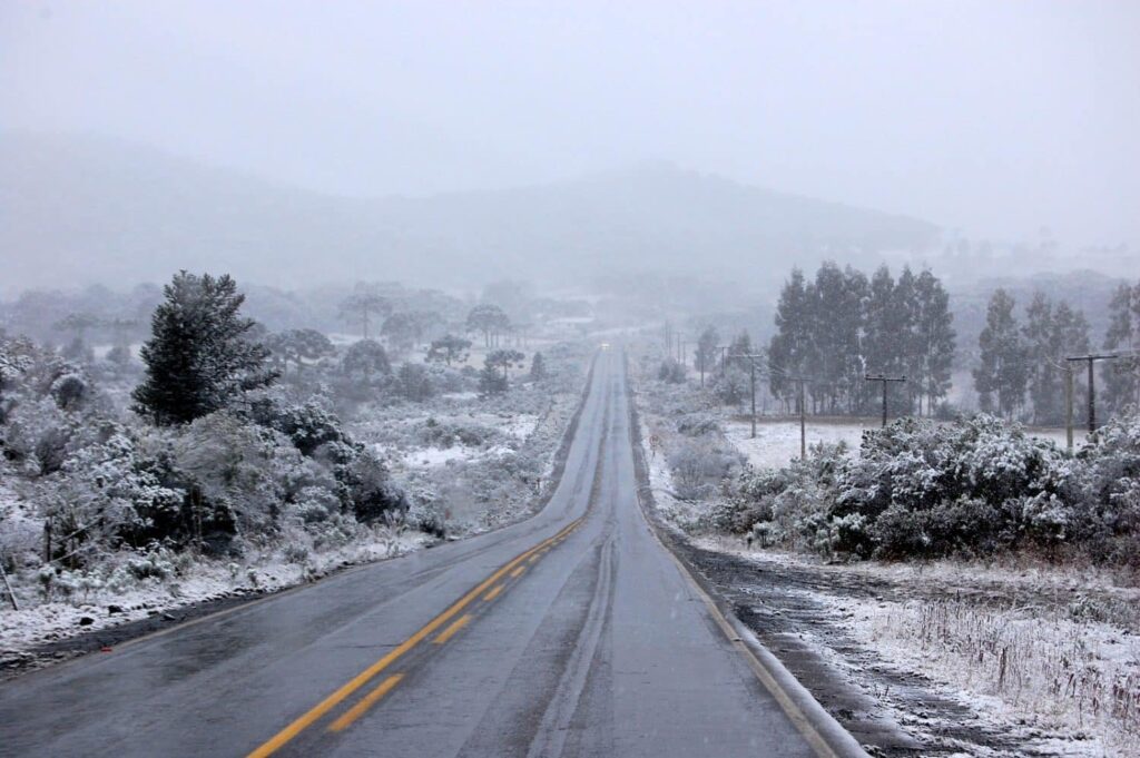
Snow is a phenomenon that needs several factors to happen, among them: extremely cold weather, altitude and humidity. Tourists are usually surprised by the snow in the months of June, July and August.
The ideal is always to research the weather before making your trip and plan for the possibility of snow 🙂
What is the city that snows the most in Brazil?
São Joaquim, the city in the mountains of Santa Catarina.
Mountain Hike – Pedra Furada Trail – São Joaquim National Park
The walk is at one of the highest points of Serra Geral, in the Church Hill, the Pedra Furada trail stands out.
It is traveled approximately 8.5 km around the top of Morro da Igreja. The difficulty of the hike can be considered moderate, requiring visitors to be physically mobile and have some experience in hiking in natural environments. The estimated duration was approx. from 5 hours, taking into account the stops to contemplate the spectacular landscapes along the way.
The objective is to reach Pera Furada! The price, including guide, insurance and authorization to access the park: is R$ 150.00 per person (Minimum 2 people – Maximum 6 people).
vulture
For those who are in the region and want to feel the cold, the suggestion is to take the car and head to Urubici. In the municipality, Morro da Igreja is located, with 1828 meters high.
The peak, where the lowest temperature ever recorded was 17 degrees below zero, is considered the coldest in southern Brazil. Even on days of mild temperature, in Morro da Igreja the temperature is always lower than in other places.
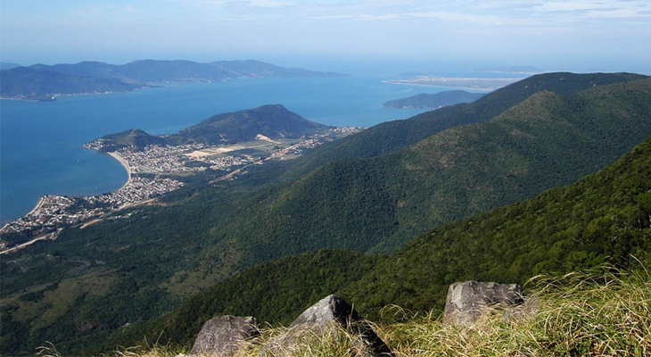
From the top of the hill, it is possible to see part of the coast of Santa Catarina and a large canyon. Urubici has less than 10,000 inhabitants and today has 17 hotel developments, including inns, farm hotels and hostels.
Main sights of Urubici
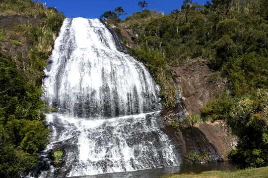
Avencal Waterfall: With 100 meters of waterfall, it is a true Urubici postcard. During the summer it is possible to take a delicious bath in the natural pool that is under its waterfall.
Morro da Igreja and Pedra Furada: considered the main postcard from Urubici, Morro da Igreja and Pedra Furada offer incredible panoramic views of the region. The place is famous for Holed stone, a peculiar and impressive rock formation.
Serra do Corvo Branco: Although not in Urubici, Serra do Corvo Branco is a nearby attraction worth visiting. This mountain road offers breathtaking views and impressive rock formations, especially in the White Crow Lookout. Below is the map that shows the distance from Urubici to Corvo Branco mountain (26km).
When is the best time to go to Urubici?
Urubici has attractions throughout the year! For those who like the cold, frost and fireplace, the option of going during the winter is wonderful. For those who like trails, waterfall bathing, the option to go during the summer is undoubtedly the best.
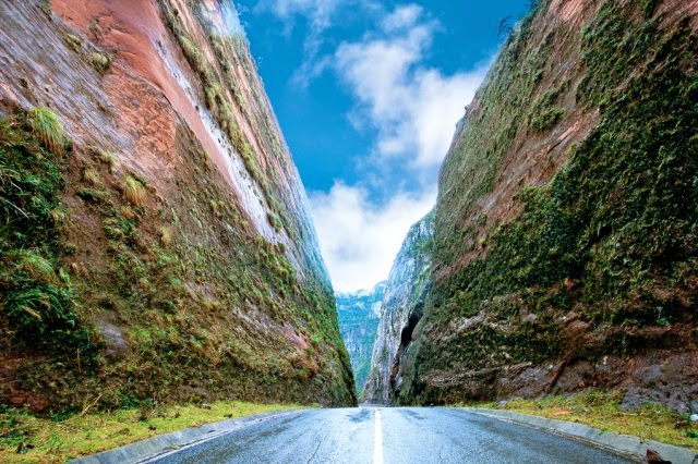
Serra do Corvo Branco
The Serra do Corvo Branco connects Urubici to the south coast with an altitude of 1470 meters. Those who have been on the road usually define the tour as an adventure.
The journey needs to be done carefully, the road is narrow and the curves are tight. The name of the Serra is a reference to a figure formed by the rocks.
Looking at the steep slopes, it is possible to see the figure of a crow.
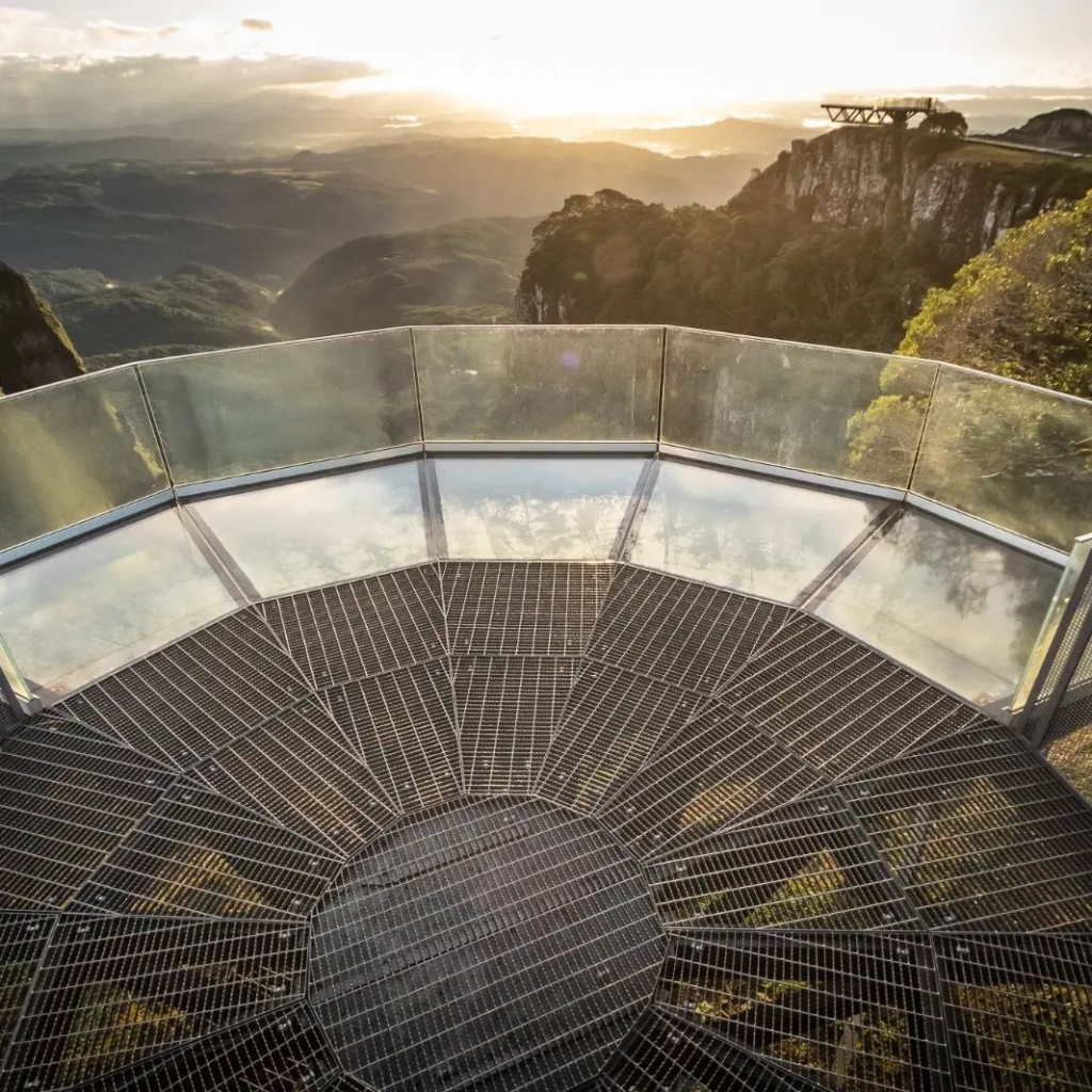
Serra do Corvo Branco: glass lookout
The lookout was built in the Altos Corvo Branco park, to access the park you have to pay an entrance fee of R$30.00 per person.
The view from the place is amazing and it's really worth it!
Urupema
This is the coldest city in Brazil! The coldest temperature recorded in Urupema occurred on the day June 29, 1996, when the thermometers marked -17.8°C. This temperature record is quite significant and reflects the harsh climate that the city can experience during the winter.
For this reason and the beautiful landscapes, the city receives many tourists during the winter. One of the most visited places is the Morro das Torres: located approx. 1,800 meters altitude, offers a breathtaking panoramic view of the region, with mountains, valleys and the typical vegetation of Serra Catarinense.
Another highlight of Urupema is the Avencal Waterfall: A beautiful waterfall located in the midst of exuberant nature. With approximately 100 meters high, it is a lovely place to enjoy the landscape and go hiking, during the coldest days of the year the waterfall is completely frozen, making the scenery stunning.
What is the closest airport to Urupema?
Florianópolis Airport is the closest airport, approximately 200km, with national and international flights.
Rufino river
Rio Rufino is really a charming little town, strategically located between Urubici and Urupema. Although less known than its neighbors, Rio Rufino offers stunning natural attractions that attract visitors in search of picturesque landscapes and moments of tranquility.
At Fábrica waterfall and Tigre River are two of the main natural attractions of Rio Rufino. Cachoeira da Fábrica is known for its imposing waterfall and surrounded by lush vegetation, it takes this name because it is a water collection point that used to run a pulp mill in the 1940s, where ruins of the old building can still be found.
The Waterfall of Rio do Tigre has a beautiful natural swimming pool, where visitors can cool off and enjoy the surrounding nature.
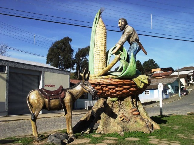
The monument in the city draws attention, a horse waiting for its owner harvesting corn.
Lagos
Lagos is located in Serrano Plateau, in the central region of the state of Santa Catarina. Located in a region characterized by fields and rural landscapes, Lages has a rich history and is known for being an important cultural, economic and tourist center in the region.
The city has a special highlight for being the place where the first farm hotels in the country. These establishments offer visitors the opportunity to enjoy an authentic rural experience, experiencing country life, participating in agricultural activities and enjoying the tranquility and natural beauty around.
Lages is known for hosting the National Pinhão Festival (usually takes place in the first week of June), an event that celebrates mountain culture and local cuisine, with emphasis on typical dishes based on pine nuts, such as pine nut paçoca and entrevero, a mixture of meat, vegetables and pine nuts.
Landmarks in Lagos
Lages has several interesting sights.
One of the best known is the Diocesan Cathedral of Lagos, a historic and religious landmark of the city, with its imposing architecture.
O Thiago de Castro Historical Museum it is also a place worth visiting to experience the local history and culture.
Skull Jump known as Praia do Lageano, in the middle of a lot of nature, lake for fishing and bathing during the summer, and water sports, in addition to the waterfall, dam, restaurants and camping.

Morro da Cruz (Mirante de Lages SC) it is a place of prayers and with a beautiful panoramic view, much visited in the holy week, many faithful walk over its 500 steps, but you have the option of going up the hill by car.
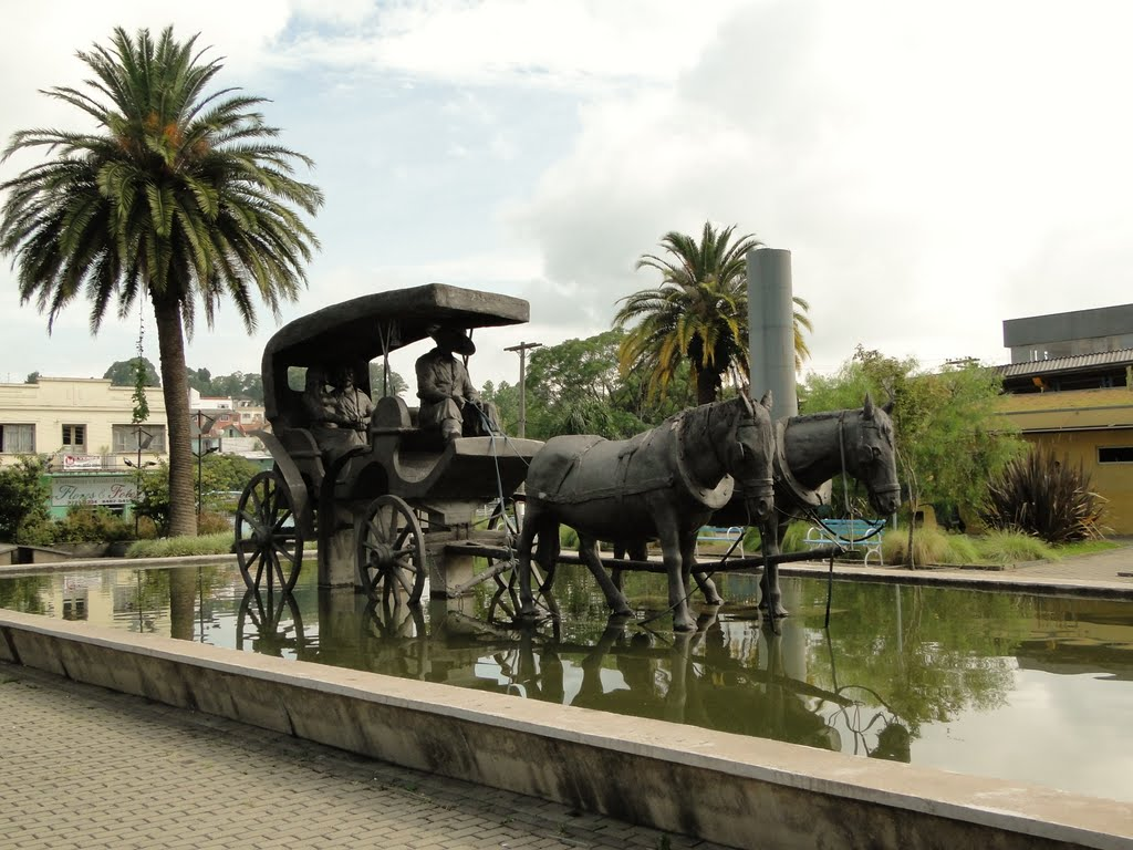
One of the places with great cultural and historical relevance is the Vidal Ramos Senior Filho Square, the place has a wagon over the waters that marks the place where the merchants brought their goods, their items to trade in the city center.
alfredo wagner
Alfredo Wagner is a city located in the Greater Florianópolis region, in the state of Santa Catarina, Brazil. Located approximately 80 km from the capital Florianópolis, the city is located in a region of mountains and has a peaceful and cozy atmosphere.
One of the main attractions of Alfredo Wagner is the Serra do Tabuleiro National Park, an area of environmental preservation that is home to a rich diversity of fauna and flora. The park offers ecological trails, waterfalls, rivers and stunning landscapes, making it a popular destination for nature and ecotourism lovers.
In addition to National park, the region of Alfredo Wagner has other natural sights, such as the Bride's Veil Waterfall, a beautiful waterfall that enchants visitors, and Morro do Tigre, which provides an incredible panoramic view of the region.
The city also preserves cultural aspects, with emphasis on the Mother Church of Our Lady of Pleasures, a historic building dating back to the 19th century and representing part of the religious history of the region.
How to Go to Serra de Santa Catarina
For those traveling by car, there are several access routes that lead to Serra Catarinense. Below is the description of the roads:
North – SC 430 connecting the municipality to BR 282 in Bom Retiro, paved road.
South – SC 430 giving access to São Joaquim and Bom Jardim da Serra, paved road.
East – SC 439 goes down the mountain reaching the municipality of Grão Pará, connecting with the BR 101 in Tubarão, an unpaved road.
West – SC 439 leading to the municipality of Rio Rufino, unpaved road.
When to go to the mountains of Santa Catarina
Serra Catarinense can and should be visited throughout the year, but it is in winter that the landscapes, combined with the very low temperatures, give this region a typically European air.
The cold in the winter season reaches temperatures well below zero, with snowfall in several locations, allowing a very beautiful view of nature and the mountains.
Where to stay in Santa Catarina
Tourism in Serra Catarinense registers a growing development, with its thematic inns and farm hotels, which offer warmth, comfort, leisure, rusticity and typical cuisine, without ever losing focus on qualified and differentiated service.
Below are some of the most sought after by tourists:
Serra Azul Hotel: Located in Urubici, Hotel Serra Azul is known for its Alpine architecture and offers comfortable and well-equipped rooms, as well as a restaurant serving mountain cuisine. The hotel also has a beautiful outdoor area with gardens and panoramic views.
Pousada das Flores: Located in São Joaquim, Pousada das Flores is a charming and cozy option. With well-decorated rooms and a welcoming atmosphere, the inn offers a delicious breakfast and has a beautiful garden for guests to enjoy.
Pousada Rural do Sesc: Located in Lages, Pousada Rural do Sesc is an ideal option for those seeking direct contact with nature. Located in a wide area, the inn offers comfortable chalets, meals included and several outdoor activities, such as ecological trails.
Hotel Fazenda Pedra Preta: Located in Bom Jardim da Serra, Hotel Fazenda Pedra Preta offers an authentic rural experience. With cozy accommodations, the hotel has a large outdoor area with a lake, trails, horses and activities such as milking and carriage rides.
What to eat in the mountains of Santa Catarina
In hotels, the menu is a separate attraction. The food is made on wood stoves, cooking is slower and the food retains its flavor and becomes more irresistible with the mixture of seasonings.
From breakfast to dinner, typical food from the region is served and many products are grown in the hotel itself. For breakfast at Rio do Rastro Eco Resort, for example, there are cheeses, cakes, biscuits, jams and dulce de leche that are produced in the resort's kitchen.
Even the fish served is caught in the property's lakes. One of the main dishes is trout in salt dough, roasted on marble stone. It is still possible to taste sheep with mint cream and frescal – meat salted before preparation and dried at room temperature – served with candied squash. As there are many araucaria trees in the region, pine nuts are found in large quantities.
Dishes are usually served with paçoca de pinhão, a typical delicacy from Santa Catarina made with crushed pine nuts and mixed with meats and seasonings.
Climate
The Sierras Catarinenses offer an extremely pleasant summer, with an average temperature of 22ºC.
And winter, even with temperatures below 0°C, is inviting and unforgettable, with frost and frequent snowfall.
Tips
- For those who want a bit of adrenaline, Urubici is becoming a meeting point for fans of extreme sports, including: abseiling, paragliding, hang-gliding, motocross and jeep. City hotels provide information on these attractions.
- Visit some of the many waterfalls, waterfalls and waterfalls in Serra Catarinense. In all, there are more than 80.
- Take advantage of the region's cold to eat a delicious fondue by candlelight.
Read too: